
Greece–Italy EEZ: Greece has proclaimed an Exclusive Economic Zone in the Ionian Sea up to Cape Tainaron (map and coordinates)
The Hellenic Republic has officially proclaimed an Exclusive Economic Zone (EEZ) in the Ionian Sea, extending southward to Cape Tainaron in the Peloponnese. Presidential Decree 33/2025 was published today April, 17 2025 in the Government Gazette (FEK 59/17.04.2025, Issue A).
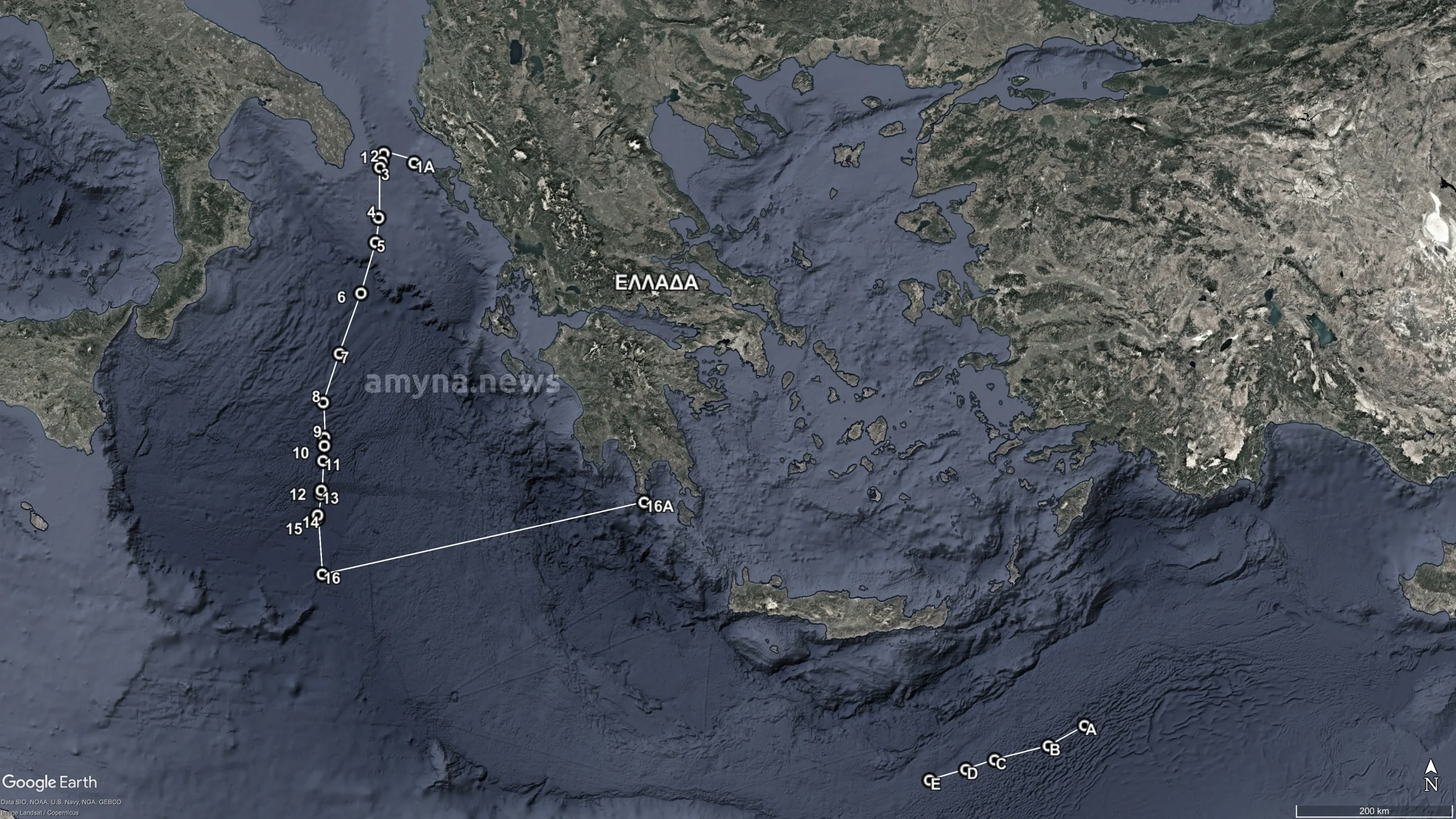
The EEZ in the Ionian Sea has been defined based on the Greece–Italy agreement on the delimitation of maritime zones and is based on 18 delimitation points.
Importantly, the newly proclaimed EEZ does not include the territorial sea of the Hellenic Republic in the aforementioned maritime area, the breadth of which was established by Law 4767/2021 (Government Gazette A’ 9), entitled “Determination of the breadth of the territorial sea in the maritime area of the Ionian Sea and the Ionian Islands up to Cape Tainaron of the Peloponnese”.
According to the proclamation, Greece will exercise sovereign rights and jurisdiction in this EEZ as provided by the United Nations Convention on the Law of the Sea (UNCLOS), particularly Parts V, VI, VII, VIII, XII, and XIII. Greece ratified UNCLOS in 1995.
Greece reserves the right to exercise the corresponding rights regarding its remaining coasts, as derived from the United Nations Convention on the Law of the Sea of 10 December 1982.
Coordinates of the EEZ in the Ionian Sea
The EEZ boundaries, in the geodetic reference system WGS-84, begin near Akra Boca (Othonoi Island) and extend through a series of delimitation points agreed upon with Italy. The zone reaches as far south as Cape Tainaron, the southernmost tip of mainland Greece.
According to Presidential Decree 33/2025, the coordinates of the EEZ are:
- 1A | 39° 52′ 06.63″ N 19° 22′ 53.34″ E [Akra Boca (Othonoi Isl.)]
- 1 | 39° 57′ 38.46″ N 18° 57′ 27.29″ E [Delimitation point between Greece and Italy – No. 1]
- 2 | 39° 52′ 20.45″ N 18° 56′ 03.29″ E [Delimitation point No. 2]
- 3 | 39° 48′ 56.44″ N 18° 54′ 51.29″ E [Delimitation point No. 3]
- 4 | 39° 17′ 14.40″ N 18° 55′ 33.31″ E [Delimitation point No. 4]
- 5 | 39° 01′ 56.39″ N 18° 53′ 57.32″ E [Delimitation point No. 5]
- 6 | 38° 29′ 56.34″ N 18° 43′ 51.32″ E [Delimitation point No. 6]
- 7 | 37° 51′ 56.29″ N 18° 28′ 33.33″ E [Delimitation point No. 7]
- 8 | 37° 21′ 14.26″ N 18° 16′ 57.33″ E [Delimitation point No. 8]
- 9 | 36° 59′ 26.23″ N 18° 19′ 03.34″ E [Delimitation point No. 9]
- 10 | 36° 54′ 20.23″ N 18° 19′ 09.35″ E [Delimitation point No. 10]
- 11 | 36° 44′ 56.22″ N 18° 18′ 33.35″ E [Delimitation point No. 11]
- 12 | 36° 26′ 26.20″ N 18° 17′ 57.36″ E [Delimitation point No. 12]
- 13 | 36° 24′ 02.19″ N 18° 17′ 39.36″ E [Delimitation point No. 13]
- 14 | 36° 10′ 56.18″ N 18° 15′ 39.37″ E [Delimitation point No. 14]
- 15 | 36° 08′ 56.18″ N 18° 15′ 39.37″ E [Delimitation point No. 15]
- 16 | 35° 34′ 08.15″ N 18° 20′ 39.39″ E [Delimitation point No. 16]
- 16A | 36° 23′ 07.09″ N 22° 28′ 58.85″ E [Cape Tainaron (Peloponnese)]
To facilitate better understanding of the geographical extent of the Greece–Italy EEZ, a map is provided depicting the area of the Greek Exclusive Economic Zone in the Ionian Sea, as defined by the listed coordinates.
It is recalled that yesterday Greece published the Maritime Spatial Planning.